yesterday's tennessee

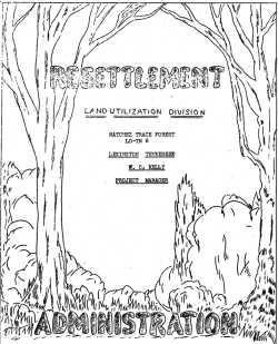
Resettlement Administration Land Utilization Division
LEXINGTON, TENNESSEE
W. C. KELLEY
PROJECT MANAGER
[circa late 1936]
Forward [sic.]
The Resettlement Administration was made possible by the Congress and ordered set up by President Roosevelt April 30, 1935, as a result of studies made by the present administration and by government agencies of former administrations.
In. order to bring together under one head several emergency organizations which had been working more or less on the same problems, the Division of Subsistence Homesteads of the Department of thc Interior; the Division of Rural Rehabilitation and the Land Program of the Federal Emergency Relief Administration; the Land Policy Section of the Agricultural Adjustment Administration and the Farm Debt Adjustment Program of the Farm Credit Administration were transferred by executive order to the Resettlement Administration.
The Administration was set up as part of the $4,800,000,000 Works Program on the principle that it presented an. opportunity to initiate a program of permanent value and at the same time provide emergency work for unemployed through development of Resettlement projects. By means of rehabilitation leans and practical guidance in farm plans, it also provided an opportunity to aid several hundred thousand distressed farm families to make a new start.
The primary purpose for which the Resettlement Administration was set up was to rehabilitate and resettle destitute and low-income farm families. In order to do this most effectively, it was necessary to go back to the causes of rural distress. The fundamental cause is that millions of acres are not being used to the best advantage. It is on this fundamental principle that the whole program of the Resettlement Administration is based. All the activities are directed toward that single vital end, to help the people in the proper use of land.
In Region IV the Program of the Resettlement Administration consists
chiefly,
(1) in the purchase of poor land areas, to take such lands out of
production or keep them from falling into production, and to develop them for
suitable uses for forestry, recreational areas and for game and fish
preserves;
(2) in the purchase of good land areas, subdividing and developing them,
to provide opportunities for resettlement for thousands of families who now
live on lands unsuited for successful agriculture;
(3) in assisting farmers, wrecked by the depression, to get on their feet
again on land where they now live, or on good land which can be rented, by
advancing them loans and advising them as to bettor methods in farm
management.
The first is called Land Utilization, the second, Resettlement and the third, Rehabilitation-in-place. The Natchez Trace Forest Project, described in this booklet, is an example of the first type only. For illustrated booklet describing all of the activities of the Resettlement Administration write,
DIVISION OF INFORMATION
Resettlement Administration
Region IV, Raleigh, N.C.
Return to Top
The Land Utilization program of the Resettlement Administration, of which the Natchez Trace Forest is a part was initiated in Tennessee by appointing Gilbert L. Cleland as State Manager on or about November 1st. 1934 for the purpose of establishing purchase areas of land known at that time as "Submarginal Land." There were finally established four Land Use Projects and three Park Projects in the State of Tennessee, not including several Resettlement Projects.
During the first year under the direction of Mr. Cleland, approximately 100,000 acres of land was surveyed and optioned for purchase, of which this project comprises approximately 50,000 acres. Payment for these lands was begun August 24, 1935 and these payments are being made as quickly as the Legal Department establishes clear titles to the land.
On November 15, 1935 all projects in the State were put under separate managers and orders were sent out to begin construction work as soon as possible. Work was started almost immediately on the Natchez Trace Forest Project and has been in continuous operation since. On May 1st. 1936, W. C. Kelly succeeded G. L. Cleland as Project Manager.
To Mr. H. O. Coats, Chief Pay Roll and Cost Clerk, with the assistance of the office personnel, is due the credit of producing this booklet, which gives a detailed description of the work being done, including road maps and directions for persons visiting the Project.

W. C. Kelley
Project Manager
Return to Top
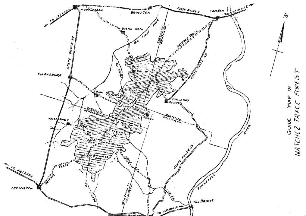
To each and all who desire to visit the Natchez Trace Forest, the Land Utilization Division of the Resettlement Administration, extends a cordial invitation. For your convenience we have pro- pared the small outline map on the opposite page.
On this map are shown the improved state routes 1, 20, 22, and 169 and the towns along each, with arrows pointing to the two cities, Jackson and Nashville. The distance from the project to the former is 30 miles, to the latter 125 miles. Those state routes are all-weather roads. From those major routes are county or secondary reads leading to and through the project.
Of those roads shown within the area the Natchez Trace and Stave Road have been relocated and are under construction. Unlike most road construction, the work as it is being carried on will not impede your tour of the project. You will marvel at the type road being built and by inquiring of those in charge will no doubt be astonished at the rapid progress being made.
The Natchez Trace Read from Lexington to Camden passes through the entire length of the Area from southwest to the northeast. Along the Trace are many things of interest to groups and individuals alike. Among these is the huge Pecan Tree with a 6½-foot diameter, located near the intersection of the Natchez Trace and the Huntingdcn, Buena Vista and Dollar road. Approximately 5 miles south of the Pecan Tree alone the Trace is found the Fairview Gullies. While viewing this wast gullied area one can more easily realize what the entire area would have been within a few short years.
The three lake sites shown on the map are under construction. The various types of work being done at these lakes include the building of dams, bath houses, lodges and recreational centers.
While visiting the various working groups in the area, we urge that you inquire of those in charge for information which space does not permit us to give here.
OUR MOTTO: "CONSERVE OUR RESOURCES AND SAVE A GREAT NATION."
Drawing, Guide Map of Natchez Trace Forest
Return to Top
The Natchez Trace Forest Project was approved for purchase October 1st, 1934 by the Land Utilization Division of the Agricultural Adjustrnent Administration in the Department of Agriculture. Two hundred and fifty thousand dollars ($250,000) was appropriated for the purchase of forty thousand (40,000) acres. This was later revised and at this date sixty-five thousand (65,000) acres are being purchased at an average price of six dollars and ten cents ($6.10) per acre.
The former County Agent, H. A. Powers, the University of Tennessee Extension Service, and Citizens of Henderson County are mainly responsible for the Natchez Trace Forest Project being purchased and developed.
The project is located, six miles northeast of Lexington, one mile east of Nashville, Chattanooga and St. Louis Railroad, thirteen miles southeast of Huntingdon, eleven miles south of Camden, the County Seats of Henderson, Carroll, and Benton Counties respectively. It is situated on the headwaters of Cub and Brown's Creek in a very depleted agricultural section. The project area is twenty-six miles long and nine miles wide and is a very isolated community as to roads. There are no hard surface nor gravel roads within the area. The type of soil makes the road impassable during the winter months. The personnel on the project was seriously handicapped in gathering data, signing options, and contacting the farm owners because of this fact. All the roads are "supposed" to be county maintained, there being no state roads in the area.,
There were 350 families on the land at the time of optioning. A large number of these families have been able to move out and resettle themselves without any assistance from the Resettlement Administration. The government has received splendid co-operation from the farm families; although in the beginning they were skeptical of all government men.
When visiting those people and acquainting one's self with them, they are very co-operative and deeply appreciative of any favor shown them. It is anticipated that these families, with the exception of forty (40) families to remain on subsistence in the project and work part-time in the forest, will be resettled on near by Resettlement Projects.
There will be approximately one hundred and twenty-five (125) families to be resettled. Everyone whom the Resettlement Administration has contacted about moving seems very interested and all desire to be relocated on land where they can support their families and increase their standard of living to that of the average American farmer.
Homer H. B. Mask, Regional Director, Region IV
James M. Gray, Associate Regional Director, Region IV
Grady L. Bain, Chief, Project Development, Land Utilization Divisioi
APPOINTED PERSONNEL
NATCHEZ TRACE FOREST PROJECT
LD-TN 6, LEXINGTON, TENNESSEE
Name, Title
W. C. Kelly, Project Manager
C. J. Bowers, Assisant Project Manager
Paul S. Simmons, Office Manager
Henry O. Coats, Chief Payroll and Cost Clerk
Marvin E. Roberts, Office Engineer
G. D. Cummings, Chief Project Engineer
Harvey L. Mook, Forester
Neal B. Wilkinson, Landscape Architect
C. Eugene Savage, Architect and Designer
D. B. Perry, Engineer Aide
Martin L. Murphy, Engineer Aide
Herbert L. Slover, .Junior Engineer Draftswan
Herbert L. Elizeor, Assistant Engineering Draftsman
W. D. Keiser, Construction Superintendent
John D. Roberts, Junior Clerk
Claude Williams, Injury Clerk
W. H. Sparks, Safety Clerk
James A. Holmes, Junior Clerk
Edmond B. Cox, Materials and Equipment Clerk
Lois Ncrris, Secretary to Project Manager
Lily McKay Ball, Secretary to Assistant Project Mgr.
Ruth L. Martin, Secretary to Office Manager
Sue Fuqua, Sec. to Chief Payroll and Cost Clerk
Elizabeth Summers, Assistant Clerk-Stenographer
Return to Top
The work on developing Natchez Trace Forest Project began in November 1935. Since then our pay roll has carried an average of 882 men each month; the number of each month ranging from 5 in November to 1399 in the last period of April l936. We have employed approximately 300 men from the Relief Rolls, about 100 Rehabilitation clients and about 350 men, who were living or working on the land acquired by the Resettlement Administration for this project. The others employed wore those who were capable and needed work.
Total Labor - 82%
Common Labor - 62%
Intermediate Labor - 12%
Skilled Labor - 6%
Professional & Technical labor - 2%
Supervisory - 7%
Administrative - 2%
Owner-Operators - 9%
[Statistics above were presented as vertical bar chart in original report.]
Return to Top
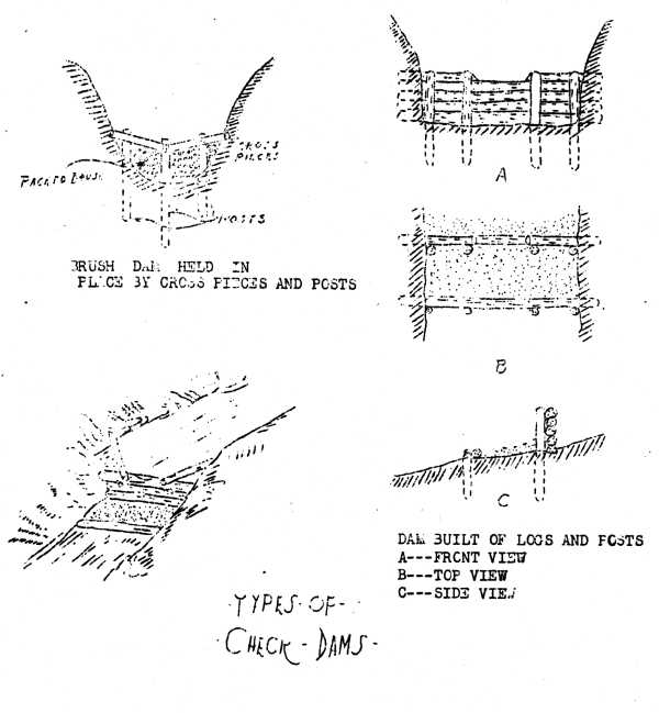
When the Resettlement Administration purchased the Natchez Trace Forest Area it was in a very depleted condition agriculturally. The area as a whole was so severely eroded that cultivation of crops was impossible on at least fifty percent (50%) of the cleared land. The soil is of such a nature that the checking of erosion is impossible without a great amount of preliminary dam construction and gully area treatment. The average person going over some of the work being done on erosion would think it was very unnecessary. Check dams made of brush, poles, and logs have done a wonderful amount of good within the three or four months they have been in use. These dams are being constructed at a very low cost because of the source of supply. During the clearing of the lake basin it was kept in mind that these poles, brush, and logs could and should be used in soil erosion on the nearest land. None of the brush or poles were hauled over one and one-fourth miles. At the present time, forest improvement work is being done. The underbrush and old logs from this work are being used in building check dams on nearby land. Soil saving dams are constructed in all ravines of the watershed leading to the lakes. These dams are being constructed of dirt fills and wooden culverts, the fill checking the water and allowing the silt to be deposited against the dirt of the basin. There has been some terracing work done on about five thousand (5000) acres in the watersheds of the three lakes being constructed. These terraces are intended to carry the water away from the lake into these soil saving dams.
There is a vast amount of soil erosion work to be done because the land embraced in the project is about sixty percent (60%), and in some cases as much as one hundred percent (100%), cleared. The land that has been cleared has been terribly butchered by poor soil management and old-time farming practices. The work being undertaken in soil erosion will show a high degree of efficiency within the next few years because of the type of. practices used.
Drawing, Types of Check Dams
Return to Top
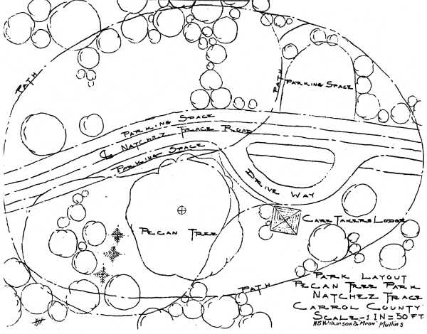
From a letter written by Mrs. Addie McCall of Huntingdon, Carroll County, Tennessee: "Quite a while ago I interviewed a very old citizen several times concerning early settlement of Carroll County, Tennessee. At the time, twenty years ago, he was 95 years of age, I did not think these talks of sufficient importance to get them signed and certified. His father was one of the very first settlers of Carroll County, and hold position of trust. His testimony is gone now, except in my memory. This man's name was Morris. His story is as follows:
The first white people in Carroll County were in the district comprising the southeast corner of Carroll County, settling there before the territory was bought from the Indians. There was a road loading from the Tennessee River at old Reynoldsburg, near what is new Johnsonville, through what is now Carroll County, and McNairy County over to Natchez, Mississippi. Since the settlement of Carroll County it has been known as the "Natchez Trace." It was called that because of the fact that some of Andrew Jackson's soldiers passed that way on their march to Natchez and this road me supposed to be the real "Natchez Trace" over which most of Jackson's men did travel."
The troops camped near the home of Morris, and from a lot of pecans gave a few to Sooky Morris. She planted sane of the nuts and from one of those grow the large pecan tree. This huge pecan tree is about six foot in diameter at the base and has a limb spread of 120 feet. It is to be preserved and the old house nearby will be restored and a small roadside park constructed around the house and tree, and we hope to be able to turn it ever to the Chapter of the D.A.R. in the vicinity of the park. This park will be just on the east side of the Natchez Trace road which we are now improving.
Drawing, Park Layout, Pecan Tree Park
Return to Top
We are to construct over 150 miles of' good roads and truck trails.
Construction on the Stave Road is now underway and great progress is being made. We have completed about 20 miles of grade, 10 miles of gravelling and all drainage structures. This road will be graded and gravelled into Wildersville. Then completed this road will be one of' the main roads through the area. The present roads in the area are almost impassible during wet weather. These roads will be a great improvement when graded and gravelled. The famous Natchez Trace Road will be graded and gravelled.
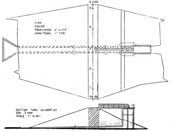
Work is now being performed on Upper Brown's Creek lake site. The dam will be 1,009 feet long, 24½ feet high with low water depth of 18 feet, and the construction of same will require 50,000 cubic yards of earth. The lake will cover 151 acres at a cost of' $143.73 per acre. At the present time piles are being driven and the muck ditch is under construction. The footing for the concrete spillway is completed.
Soon construction will start on Upper Cub Creek Lake. This dam will be 470 feet long, 22½ feet high with low water depth of 15 feet, and will require 25,000 cubic yards of earth. The lake will cover 58 acres at a cost of $288.55 per acre.
The dam at Maple Creek will be 730 feet long, 22½ feet high with low water depth of 15 feet, and will require 35,000 cubic yards of earth. The lake will cover 93 acres at a cost of $188.01 per acre.
Each lake will have a bathing beach, bath house, and diving towers. Located around the shore will be a number of cabins. These sites will be serviced with electric lights, water, and sewage. A number of' picnic' areas, with camp fixtures, parking areas, and shelters will also be located around the lakes. On upper Brown's Creek Lake a 4-H Club Recreational Camp for boys and girls will be constructed.
We have our own telephone system which will serve all points of interest. We operate our own rock quarry and gravel pit. We are to manufacture 500,000 bricks, 350,000 of which are completed.
When our work is completed we will have constructed 250,000 check dams and covered 5,000 acres of gulley treatment. Plans are now being drawn for an Administrative Building and Caretaker's Houses.
Drawing, Dam Cross-Section
Return to Top
The area selected for the 4-H Club Camp is a ridge of land between two arms of Brown's Creek Lake at the upper end. This area contains approximately 20 acres and is nearly surrounded by water.
The area is heavily wooded with some fine specimens of oak, gum and maple.
The camp is laid out on the cottage plan with about 16 cottages, 2 shower houses, and 2 council houses with a mess hall and recreation lodge. This camp is to have modern plumbing and electric lighting.
The cottages are to be divided into 2 groups for the boys and girls respectively.
The diving pier is located at the point of the ridge to obtain deep water. The swimming pier and lookouts are nearer the camp proper for convenience.
The drive terminates at the recreation lodge and most of the development lies below this point with numerous woodland paths connecting the various points of interest.
The contours of the land and the various views and outlook has been taken into account in the location of the buildings and walks. There will be some restrained landscape planting in the proximity of the buildings.
Return to Top
The general landscape scheme for the Natchez Trace Forest should not be naturalistic but natural. Any work that is done should look as though it had always been there. This is going to be somewhat of a problem as man has already left his mark to a very marked degree. The scars that have been left by his occupation and the following erosion is a condition and not a theory.
As the road follows the ridge several fine views are obtainable and these should be left open and attention called to them for the pleasure of the tourist.
Entrances to the forest should be of a simple substantial type with a feel of its being at home with its surroundings. All the main roads should be developed as an example of how the highways in West Tennessee ccan be made attractive at small cost.
[Note: Page probably missing here.]
The recreational program at Natchez Trace Forest is governed by the following factors:
Return to Top
The principal recreational area is located on Cub Creek about one and one half miles from the junction of the Natchez Trace with the Old Stave Road. By the building of a dam 400 foot long the water will be backed up covering approximately 60 acres. This lake will have a wooded shore line and some fine vistas. There will be opportunities for bathing, swimming, and boating on the lake.
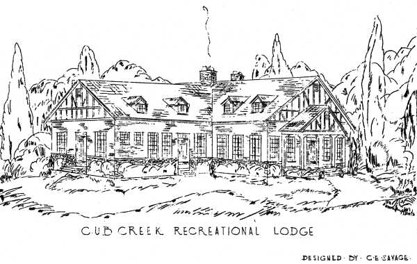
The main scheme calls for the development of the main ridge coming down between the two main arms of the lake, The center of this development will be the Recreational. Lodge located on a strategic spot overlooking the lake toward the dam on one side and up the other arm of the lake. The exterior of the Recreational Lodge is designed in a manner to fit into its surroundings and the area there about will be planted in a naturalistic style with restraint as the keynote. On the main road coming to the Lodge there will be ample parking space for this area.
Leading down from the Lodge are woodland paths leading to boat docks and picnic areas.
The picnic areas will be filled with benches, seats, and outdoor fire places along with picnic shelters and available water supply.
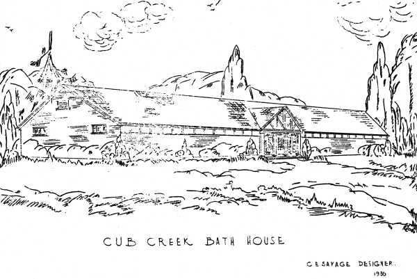
The next most important building on this area is the bath house and the beach. The beach will be of sand and the bath house modern with parking space in front for about 30 cars.
Farther up the lake in a wooded dale will be another picnic area and a kiddies play ground. Here will be located the overflow parking area for the lower levels. This area will be fitted with shelters, fire places, and water faucets.
On the North side of the ridge West of the lodge will be located the outdoor theatre with a seating capacity of about 2,500.
The drives and paths loading from one feature to the other have been planned in relation to the contour of the land and ease of curvature.
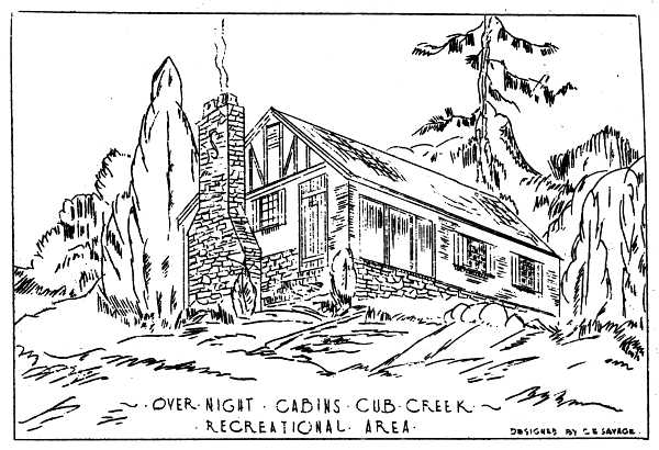
Drawing, Over Night Cabins Cub Creek
Recreational Area
Drawing, Cub Creek Bath House
Drawing, Cub Creek Recreational Lodge
Return to Top
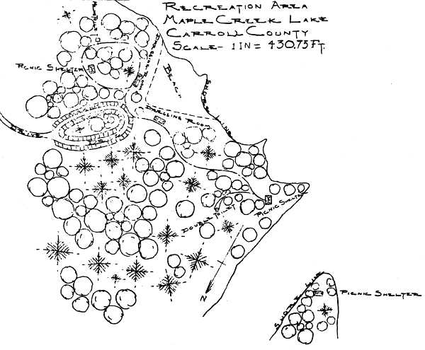
The main feature of Maple Creek Recreational Area is the beach. It contains a fine sandy beach with a good supply of fresh water.
The men and women will have dressing rooms on opposite sides of the beach with wood bordered paths leading past thorn to the, picnic shelters and other points of interest. The Maple Creek Area is iinteresting in that it has a rather heavy growth of evergreens.
There will be ample parking space at the beach.
Drawing, Recreational Area, Maple Creek
Lake
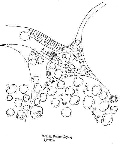
Drawing, Typical Picnic Ground
Return to Top
One of the main purposes of the Resettlement Administration in the purchase of farm lands, which have proved unfit for agricultural use, is to reclassify this land, develop it into an area which will increase its value and conserve its natural resources. Of the 50,000 acres more or less included within the boundary, 46 per cent is classed as forest and 54 per cent as cleared in farm land and pasture. The farm lands have utilized almost exclusively f or cotton growing with its accompanying deterioration of soil fertility and serious erosion. The pasture lands have been neglected and many are almost completely eroded or covered by a growth of persimmon, sassafras, blackberry, etc.. Only about 3,000 acres of good agricultural land exists on the area. The remainder of the area consists of poor pasture, waste lands, forests and cleared lands not suited for agriculture. The cleared areas should be reforested by planting where necessary and the forest land improved by sivilcultural practices and by underplanting.
In order to proceed with a definite forestry plan of development, the forestry department is making a type map and forest survey, which will show the location, size, quality and amount of all standing timber; the size, location and soil conditions of all fields and pasture lands; the location of all boundaries, roads, streams, buildings, etc. From this map and the accompanying facts, all future reforestation will be planned.
Our reforestation program for 1936 called for the planting of 2,000,000 seedlings in the spring and 100,000 in the fall. To date we have planted about 1,800,000 seedlings, including Black Locust, Loblolly Pine, Slash Pine, Longleaf' Pine and Yellow Popler. These seedlings have come to us from nurseries of Tennessee, Indiana and West Virginia. The 1936 fall planting season calls for 100,000 Black Walnuts to be spot planted in the field. It is expected that about 25,000,000 seedlings of different species will have to be planted to reforest all the open and waste lands.
Due to the uncertainty when purchasing seedlings from outside sources, it was decided to start our own nursery. We planned on having 15 acres of which 5 acres were to be Black Locust, 7 acres of Pine and 3 acres of Cedar. We will have about 2,000,000 seedlings ready for the 1937 spring planting season.
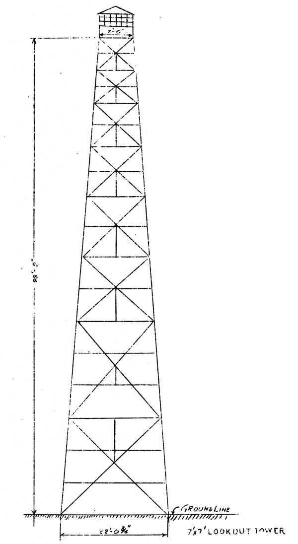
To protect this area from fire, adequate fire protection is planned. Two 60 foot steel fire towers are to be erected; one in the north end and the other in the southern part of the property. From these two lookout towers the entire area can be seen and during periods of the year when conditions are favorable to fire, a man will be stationed in each tower to keep a close watch over the whole area. A fire break is to be built and maintained around the entire area. This is to consist of a line following the outside boundary on which for a width of eight feet all brush and most of the trees are to be cut. Then a path or trail 4 feet wide is to be built in which all grass, etc. is to be cleaned off. This path will afford a means of access to any point on the boundary and afford a starting point to check any fire burning in from adjoining properties.
Over one million feet of lumber of all kinds is called for to complete the building program of this project. Although the timbered area has been heavily culled, large amounts of second grade oak and some first grade yellow poplar and other soft woods were left. This timber is being cut under forestry supervision; seed trees, young timber and open stands are being protected. Only that timber which stood in the lake sites and mature trees are being cut. A dry kiln and complete planing mill have been set up on the property and this lumber will be manufactured into building material such as flooring, siding, interior trim, etc. At the beginning of July 1936 more than 700,000 feet of lumber had been cut and 55,000 oak boards for shingles made.
Drawing, Lookout Tower
top · home · yesterday's · families · schools · links · what's new · memorial · about
This site was created by David Donahue and Brenda Kirk Fiddler.
This site is currently maintained by Jerry L. Butler
Copyright © 2004 - 2010, All rights reserved